








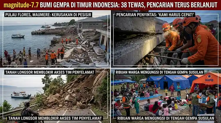
A massive Indonesia earthquake measuring magnitude 7.7 tore through the eastern part of the archipelago before dawn on Saturday, killing dozens of people, trapping residents under collapsed buildings, and sending a brief tsunami warning racing across three provinces. The quake, centered off Flores Island in East Nusa Tenggara province, is now being described by officials as one of the most destructive seismic events the region has experienced in more than three decades.
Rescue crews are still struggling to reach the hardest-hit villages as landslides block roads and communication networks remain down in several regencies. This article breaks down everything currently known about the disaster, including the rising death toll, eyewitness accounts, the science behind why Indonesia keeps getting hit this hard, and what residents should do if aftershocks continue.
A Powerful Pre-Dawn Jolt Off Flores Island
According to the United States Geological Survey (USGS), the earthquake struck at roughly 5:58 a.m. local time, with its epicenter located about 68 kilometers northwest of the city of Ende in East Nusa Tenggara province. USGS measured the depth of the rupture at around 10 kilometers, a shallow depth that typically produces stronger shaking at the surface.
Indonesia’s own geophysics agency, BMKG, recorded the initial shock slightly earlier, placing it at a depth of about 15 kilometers, and noted that it was followed almost immediately by a string of aftershocks. Within the first half hour alone, at least three significant aftershocks followed the mainshock, with magnitudes reported between 5.6 and 6.1.
Officials say the shaking was violent enough to be felt clearly across East Nusa Tenggara, West Nusa Tenggara, and parts of South Sulawesi, with residents in multiple towns describing tremors that lasted close to a full minute. The National Disaster Management Agency, known locally as BNPB, said in a statement that most people who felt the shock ran out of their homes in panic, with many still in their nightclothes.
Death Toll Rises As Rescue Operations Widen
The human cost of the disaster has climbed steadily throughout the day as rescue teams push into more remote areas. By mid-afternoon local time, BNPB chief Suharyanto told a televised press briefing that the agency’s tally stood at 38 fatalities, alongside two people seriously injured and eleven with minor injuries. He added that around 2,000 residents had fled to higher, safer ground as a precaution.
That figure marks a sharp jump from earlier in the day, when international outlets citing local officials and the USGS reported a toll in the low double digits. The gap illustrates how quickly casualty figures can shift in the opening hours after a major earthquake, particularly in a disaster zone spread across multiple islands with patchy phone and internet coverage. Readers should expect the number to keep moving as search-and-rescue teams reach isolated villages over the coming days.
Maumere Port Town Hit Hardest
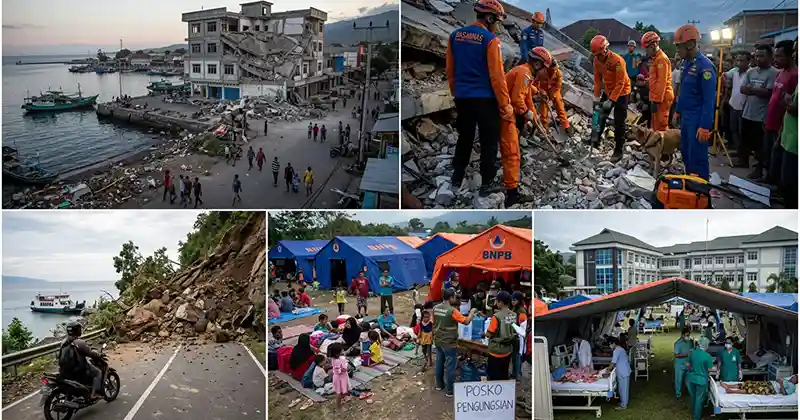
The port town of Maumere, the main hub of Sikka Regency on Flores Island, has emerged as one of the worst-affected areas. Fathur Rahman, head of the city’s rescue agency, told Reuters that rescuers there had already recovered 20 bodies, with six people injured and two more still trapped beneath rubble.
Video verified by Reuters and shared on social media showed part of a building at a Maumere port terminal crumbling into a cloud of dust and debris while people screamed and scattered into the street. A local resident, Yohanna Embu, said several structures in the area were damaged, including the waiting room of the port terminal, which collapsed during the shaking.

Nagekeo Regency Cut Off From Rescue Teams
The regency closest to the earthquake’s epicenter, Nagekeo, has proven the hardest to reach. Communication signals in the area were knocked out by the quake, leaving officials with only fragmented information about conditions on the ground. Fathur Rahman told Reuters that attempts to reach Nagekeo by road had been blocked by landslides, forcing one rescue team to attempt an approach by ferry instead.
BNPB reported that roughly 2,000 residents of Nagekeo evacuated their homes, and that houses, warehouses, and government buildings in the regency sustained damage. The agency also confirmed traffic congestion and power outages affecting parts of the district, complicating both the rescue effort and the flow of information to the outside world.
Indonesia’s East Nusa Tenggara governor, Emanuel Melkiades Laka Lena, said at a separate briefing that at least five people died after being buried under rubble while they slept, underscoring how the pre-dawn timing of the quake left many residents with almost no time to react.
Tsunami Warning Issued, Then Lifted
Within minutes of the initial shock, Indonesia’s Meteorology, Climatology and Geophysics Agency issued a tsunami warning covering East Nusa Tenggara, West Nusa Tenggara, South Sulawesi, and Southeast Sulawesi provinces, urging coastal residents to move away from beaches and riverbanks immediately.
Small tsunami waves, generally under one meter in height, were subsequently recorded in several coastal areas, including reports of waves reaching close to a meter in Maurole, part of Ende regency. The warning was formally lifted roughly three hours after the earthquake struck, once monitoring agencies determined the threat of a larger wave had passed.
Authorities outside Indonesia also weighed in quickly. Australia’s tsunami warning centre said the undersea earthquake posed no tsunami threat to the Australian mainland, its islands, or its territories, a reassurance that came even as Indonesian coastal communities were still being told to stay on alert.
Eyewitness Accounts: “The Shock Was So Strong”
Residents across the affected provinces described a night of terror as the shaking jolted them awake. Nona, a 51-year-old resident of Talibura village in East Nusa Tenggara, recalled resting at home with her family when the quake hit. She said thirteen people were inside the house at the time, and that everyone ran outside together to save themselves as the ground shook violently beneath them.
Another resident, Yoan Rinto, told Reuters he was asleep when the earthquake struck and remained deeply shaken hours afterward, describing lingering anxiety about further tremors. Footage from national search-and-rescue teams broadcast by local media showed crews digging through piles of broken concrete and twisted metal, calling out for survivors as onlookers watched anxiously from a safe distance.
At a hospital in the Ende district, footage from Kompas TV showed staff evacuating patients outdoors as a precaution against aftershocks and further structural damage, while Kompas.com reported at least one landslide in the surrounding hills.
Aftershocks Continue to Rattle the Region
Seismologists have tracked a rapid sequence of aftershocks since the initial rupture, some strong enough to cause fresh panic on their own. India’s National Center for Seismology recorded a follow-up earthquake of magnitude 6.3 in the Flores Sea, the body of water separating Flores from Sulawesi, at a depth of around 63 kilometers, roughly 15 minutes after the mainshock. A third quake, measuring magnitude 6.0, struck the same area at a depth of about 42 kilometers shortly after that.
The USGS separately estimated that approximately 500,000 people were exposed to very strong or severe shaking during the sequence, a scale of exposure that helps explain the widespread, simultaneous reports of building damage across so many towns at once. BMKG has urged residents throughout the region to remain alert for further aftershocks in the coming days, a standard precaution following a mainshock of this magnitude.
Why Indonesia Is So Vulnerable: Living on the Ring of Fire
Indonesia’s staggering earthquake frequency is not a coincidence of bad luck; it is a direct consequence of geography. The country sits squarely on the Pacific “Ring of Fire,” a horseshoe-shaped belt stretching around the edges of the Pacific Ocean where several of the Earth’s tectonic plates grind against one another. This zone is responsible for roughly 90 percent of the world’s earthquakes and is also home to the majority of the planet’s active volcanoes.
Flores Island itself sits near the boundary where the Australian and Sunda plates interact, a collision zone that has produced some of Indonesia’s most destructive earthquakes. Because so many of these ruptures occur offshore and at relatively shallow depths, they carry a heightened risk of triggering tsunamis in addition to the ground shaking itself, which is exactly why authorities moved so quickly to issue a tsunami warning after Saturday’s quake.
Echoes of the Deadly 1992 Flores Earthquake and Tsunami
For long-time residents of the region, Saturday’s disaster likely stirred painful memories. Indonesian officials noted that the same stretch of coastline was struck by a similarly powerful magnitude 7.5 earthquake in 1992, an event that caused extensive destruction at the time.
According to background compiled on that disaster generated a tsunami with waves reported as high as 26 meters in some coastal areas and killed somewhere between 2,080 and 2,500 people, with estimates of the injured ranging as high as 2,144. The 1992 event remains one of the deadliest earthquake-tsunami disasters in modern Indonesian history and is frequently cited by seismologists studying the long-term hazard profile of the Flores fault system.
While Saturday’s death toll has not approached the scale of the 1992 catastrophe, the geological parallels have prompted renewed scrutiny of building codes and early-warning infrastructure in East Nusa Tenggara province, an area that remains one of Indonesia’s poorer and more geographically isolated regions.
Damage to Homes, Hospitals, and Infrastructure
Beyond the human toll, Saturday’s earthquake has left a wide trail of structural damage across East Nusa Tenggara province. BNPB’s early assessment pointed to damaged houses, warehouses, and government facilities in Nagekeo regency alone, while local reports out of Sikka described a collapsed waiting area at the Maumere port terminal and cracked walls in several nearby shopfronts.
Power outages were reported in parts of Nagekeo, complicating both rescue coordination and the ability of residents to charge phones or access news updates. Traffic congestion also built up quickly on the limited road network connecting the province’s towns, as evacuees moved toward higher ground and emergency vehicles tried to push in the opposite direction toward the disaster zone.
Hospitals were among the first facilities to take precautionary action. In Ende district, footage broadcast by Kompas TV showed hospital staff moving patients out of wards and into open courtyards, a standard precaution in Indonesia when aftershocks threaten already-stressed buildings. Similar evacuations were reported at smaller clinics across the province, though officials have not yet released a full account of how many medical facilities sustained structural damage.
Local reporting also flagged at least one landslide in the hills around Ende, adding another hazard for both residents and rescue convoys attempting to navigate the region’s mountainous terrain. Landslides are a recurring secondary danger after large earthquakes in Flores, where steep, saturated slopes can give way even hours or days after the initial shaking stops.
How Indonesia’s Disaster Agencies Are Responding
BNPB has taken the lead in coordinating the national response, working alongside regional search-and-rescue teams, the Indonesian National Police, and local volunteers. The agency confirmed it had deployed a helicopter to support ground teams, citing the province’s fragmented, multi-island geography as one of the single biggest obstacles to a fast response.
Because Nagekeo, the regency closest to the epicenter, lost much of its communications infrastructure in the quake, officials have had to rely on intermittent radio contact and on-the-ground reports relayed by teams that eventually fought through blocked roads. One rescue unit attempted to reach the regency by ferry after road access was cut off by landslides, illustrating just how quickly a major earthquake can isolate an entire district from the rest of the country.
Indonesia’s broader disaster-management framework, built up significantly since the catastrophic 2004 Indian Ocean tsunami, includes a network of seismic sensors and coastal sirens designed to shorten the gap between a quake and a tsunami warning. That system appears to have functioned as intended on Saturday, with BMKG issuing its warning within minutes of the mainshock, even though the actual wave heights that followed turned out to be modest.
A History of Destructive Earthquakes in the Region
Saturday’s disaster adds to a long and difficult history of seismic events along Indonesia’s eastern islands. In addition to the catastrophic 1992 Flores earthquake and tsunami, the wider Indonesian archipelago has experienced numerous major quakes over the past two decades, including the 2004 magnitude-9.1 earthquake off Sumatra that triggered the Indian Ocean tsunami, and a series of destructive quakes on Sulawesi and Lombok in more recent years.
That repeated exposure has shaped how seriously officials treat every major tremor along the Ring of Fire, even when initial reports suggest a relatively contained impact. Indonesian authorities have consistently erred on the side of issuing tsunami warnings quickly after offshore quakes, reasoning that a false alarm is far preferable to a delayed evacuation in a coastal community with only minutes of warning time.
Geologists studying the Flores back-arc thrust, the fault system believed responsible for both the 1992 quake and Saturday’s rupture, have long flagged the area as one of Indonesia’s most hazardous, given its combination of shallow rupture depths, proximity to densely populated coastal towns, and history of generating locally destructive tsunamis even from moderate-sized earthquakes.
International Media and Monitoring Response
Global outlets moved quickly to cover the unfolding disaster. Reporting from Al Jazeera and CNN tracked the rapidly rising casualty figures throughout the day, while the USGS earthquake hazards program continued to refine estimates of the quake’s magnitude, depth, and shaking intensity as more seismic data came in. Indonesia’s BNPB has said it deployed helicopters alongside ground emergency response teams, citing the archipelago’s scattered island geography as one of the biggest obstacles to reaching victims quickly.

What To Do During an Earthquake and Tsunami Warning
For residents living along Indonesia’s coastlines, and for anyone in a seismically active region, disaster preparedness experts recommend a few key actions during and immediately after a major earthquake:
- Drop, cover, and hold on during the shaking itself, staying away from windows, glass, and heavy furniture that could topple.
- Move to higher ground immediately if you are near a coastline and feel strong or prolonged shaking, even before an official tsunami warning is issued, since waves can arrive within minutes.
- Avoid damaged buildings after the shaking stops, as aftershocks can bring down structures already weakened by the initial quake.
- Keep a battery-powered radio or a charged phone on hand to receive updates from agencies like BMKG or BNPB, since cellular networks in disaster zones frequently go down.
- Check on neighbors, especially the elderly, since many injuries in events like this occur when people are trapped or cannot evacuate quickly on their own.
- Do not return to the coast until local authorities formally lift a tsunami warning, even if the sea appears calm.
These steps mirror the guidance issued by Indonesian authorities throughout Saturday’s emergency and are consistent with broader tsunami-preparedness advice published by international disaster agencies.
Frequently Asked Questions About the Indonesia Earthquake
What caused the Indonesia earthquake? The earthquake was caused by tectonic movement along a fault system near Flores Island, part of the seismically active Pacific Ring of Fire where the Australian and Sunda plates meet.
How strong was the earthquake? The quake measured magnitude 7.7, according to both the USGS and Indonesia’s BMKG agency, making it one of the strongest to hit the region in years.
Was a tsunami confirmed? Small tsunami waves under one meter were recorded in a few coastal areas, and a formal tsunami warning was issued and later lifted roughly three hours after the quake.
Which areas were hit hardest? Sikka Regency, particularly the port town of Maumere, and Nagekeo Regency near the epicenter reported the most severe damage and casualties.
Is this related to the 1992 Flores earthquake? It struck the same general coastline as the deadly 1992 magnitude-7.5 earthquake and tsunami, though the two events are separate occurrences decades apart.
Conclusion: A Region Bracing for More Aftershocks
Saturday’s magnitude 7.7 earthquake has left eastern Indonesia in a state of emergency, with rescue teams racing against blocked roads, downed communications, and the ever-present risk of further aftershocks to reach survivors in Nagekeo, Sikka, and surrounding regencies. As officials continue updating casualty figures and damage assessments, the disaster is a stark reminder of the seismic hazards facing communities that live along the Pacific Ring of Fire, and of how quickly a pre-dawn tremor can upend entire towns.
Authorities have urged residents throughout East Nusa Tenggara and neighboring provinces to remain vigilant, stay away from damaged structures, and follow official guidance as the search for survivors continues in the coming days.
This article will be updated as rescue operations continue and new information becomes available from Indonesian authorities and international monitoring agencies.

Economic Affair
- Budhigandaki Flood: 47 Rescued as Bridges Washed Away
- Nepal Supreme Court Handcuff Order: Police Barred From Routine Use
- 250+ Officials Deploy to Assess Rasuwa-Bhotekoshi Flood Damage
- Electricity VAT: Energy and Finance Ministers Strike Landmark Deal After Just 2 Months
- Nepal Inflation Shockingly Triples to 5.96% — Food and Transport Hit Hardest


Comments